

A large-scale framework for estimating soil carbon, nitrogen, pH, and salinity dynamics for 1985–2023
Matteo Dalle Vaglie, Saverio Francini, Gherardo Chirici, and Federico Martellozzo
PNAS; May 26, 2026; 123 (22) e2534913123; https://doi.org/10.1073/pnas.2534913123
Significance
Soils underpin food production, regulate the climate, and sustain terrestrial ecosystems, yet their condition is shifting rapidly under the combined pressures of human activity and climate change. Understanding how soils respond across decades, and where those responses diverge, is a prerequisite for informed land-management decisions. HUMERIS addresses this need by providing a global soil dataset at 1 km resolution that spans nearly four decades (1985–2023). Through the integration of ground-based soil samples with satellite observations, the framework reconstructs the evolution of four key properties, salinity, pH, nitrogen, and organic carbon, revealing contrasting trajectories across biomes and land-use types. These patterns offer a foundation for targeted strategies to address land degradation and support resilient ecosystem and land-use policies.
Abstract
Soil is fundamental to sustaining life on Earth, providing ecosystem services, regulating climate, and playing a central role in global food systems. In the last decades, due to human activities and climate change, soils worldwide have experienced substantial changes in their key properties, resulting in alterations to their functions. In this context, global soil mapping is crucial for identifying degradation trends and informing effective adaptation strategies. To address these challenges, this work leverages advances in machine learning and cloud computing to develop HUMERIS, a global dataset spanning 1985 to 2023 and covering four key soil properties: salinity (ECe), pH, nitrogen (N), and organic carbon (OC) across natural ice-free land surfaces globally. The goal of HUMERIS is to create a framework able to predict long-term soil dynamics across spatial scales, time, and depth. For topsoil over the reference period, the analysis suggests an increase in N (+0.4% per year) and OC (+0.5% per year), associated with a decrease of ECe (−0.2% per year) and stable values of pH. Looking at biomes and land cover classes two contrasting dynamics emerge. Colder regions show an increase in predicted OC and N compared to warmer ones, while land-use analysis reveals that areas converted from natural to cropland exhibit a relative decrease of −0.2%. These results suggest shifts in global soil properties with implications for agroecological modeling, socioeconomic analysis, and sustainable land management.
See https://www.pnas.org/doi/10.1073/pnas.2534913123
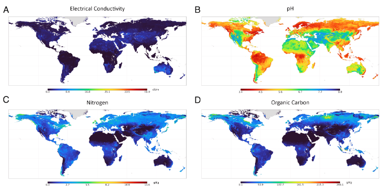
Figure 2:
Global distribution of interannual mean values (1985–2023) for four soil properties: ECe (A), pH (B), N (C), and OC (D). Color gradients represent the magnitude of each property, revealing distinct spatial patterns shaped by climatic, geomorphological, and land-use.
Views: 12