|

 Curently online :
10 Curently online :
10 |
|
 Total visitors :
7487775 Total visitors :
7487775 |
|
|
Drones help farmers in the Philippines prepare for climate disasters
Wednesday, 2016/04/27 | 07:54:16
|
|
New tech allows for rapid and detailed assessments of vulnerable farmlands
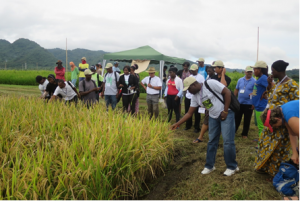
Figure: Drones are capable of covering up to 600 hectares a day and should significantly accelerate the process of risk analysis.
FAO 25 April 2016 - In a bid to stay ahead of the negative impacts of climate change, floods and typhoons on food security, the Government of the Philippines and FAO have started using unmanned aerial drones to assess where farmlands are most at risk from natural disasters and quickly assess damages after they strike.
Under a pilot phase of the still-fledgling project funded by the Ministry of Agriculture of the Philippines and the FAO, two drones have already been sent soaring over the Philippines provinces that have been affected by the current El Niño.
Some 25 FAO and government technical experts are ready to be deployed across the archipelago to support drone missions. They were recently trained over three weeks on how to fly the drones and learned a range of remote aerial assessment methods.
The drones are equipped with navigation and photogrammetric equipment that can generate detailed and data rich maps from aerial photographs including Normalized Difference Vegetation Index or NDVI, a formula used for assessing vegetation and plant health.
Data gathered can be used to see where agricultural systems are at particular risk from natural disasters -- and identify ways through which such risks can be countered, for example, through ground contouring, building retaining walls, or planting protective vegetation.
Capable of covering up to 600 hectares a day, the drones should significantly accelerate the process of risk analysis, according to Christopher Morales, Director of Field Operations for the Philippines Department of Agriculture.
"It is efficient, it saves time and we will be using a reliable source of data so that we can plan and provide appropriate interventions and responses for our farmers in times of disasters and calamities," he says.
"Additionally, imagery generated from drone flights can reveal where agricultural infrastructure projects and service facilities like irrigation or storage facilities could be sited to best serve local farmers. The technology can also potentially support in the assessment of coastal and forest areas." said Jose Luiz Fernandez, FAO Representative in the Philippines.
A new tool for countries at risk from natural disasters
The Philippines is among the world's most at-risk countries for tropical storms and other disasters.
Over the past decade, earthquakes, typhoons and floods have claimed thousands of human lives and periodically left parts of the archipelago's infrastructure and economy in tatters.
Such disasters impact heavily on farms and food systems, leaving people without food in their immediate aftermath and undermining food production capacity for years afterwards.
Approximately 20 strong typhoons affect the Philippine Area of Responsibility each year. In 2013, Typhoon Haiyan alone devastated 600 000 hectares of farmland and caused over $700 million in damage to the agriculture sector. In addition, the country is also highly vulnerable to other natural hazards such as drought, flooding and volcanic eruptions.
The vulnerability of the agriculture sector to natural hazards is evident elsewhere across the globe as well. Nearly a quarter of all damages inflicted by natural hazards such as drought, floods storms or tsunamis in the developing world are absorbed by the agriculture sector, FAO studies have shown.
Preparing for such events and taking steps to reduce risks to farmers and farming systems can greatly reduce such damages and avoid the need to build agriculture back from scratch following a disaster. |
|
|
|
[ Other News ]___________________________________________________
|
(31).png "Drones help farmers in the Philippines prepare for climate disasters")