|


 Curently online :
63 Curently online :
63 |
|
 Total visitors :
7652814 Total visitors :
7652814 |
|
| Community mapping in Vietnam: lessons learned |
|
We recently deployed participatory GIS mapping in Vietnam, to monitor land use changes resulting from climate changes at plot level. Following a three-day intensive training course, six groups started conducting surveys in 100 selected households in the climate-smart village of Ma, in Vietnam’s Yen Bai province. |
|
CIAT 2015-12-07 by Georgina Smith Written by: Nguyen Duy Nhiem and Pham Thi Mai Huong Edited by: Georgina Smith http://dapa.ciat.cgiar.org/community-mapping-in-vietnam-lessons-learned/
We recently deployed participatory GIS mapping in Vietnam, to monitor land use changes resulting from climate changes at plot level. Following a three-day intensive training course, six groups started conducting surveys in 100 selected households in the climate-smart village of Ma, in Vietnam’s Yen Bai province.
The protocol we used in the exercise was a modified version of one developed and used in Peru, adapted to the fragmented field plots in Vietnam. Together with socio-economic data, we will use the results to analyze future climate scenarios, and advice agricultural technologies and practices which will then be tested in field trials.
Learning by doing
We realized that for participatory surveys in general – and pGIS specifically – adapting the questionnaire to the local context is crucial. We also had the opportunity to interact with the community, and did some learning too.
The village community had good knowledge about agricultural cultivation techniques of local farmers in the area, and many were familiar with the forested mountain area’s complex topography. Mr. Duc, a member of Cao Lan ethnic minority group, the major ethnic group in the village, said:
“I became more sociable after joining the pGIS team because I was very shy and too busy to talk to others in village; I also learned from others about chicken rearing and how to grow vegetable better. I would definitely like to join the survey team again.”
Key roles in the community
We noted that the village head has a very important role in the remote areas of Vietnam. In the beginning, despite careful explanation from the pGIS team about the aim of the survey, some people had concerns about how the data collected by the teams would be used.
But once this was explained by the enthusiastic village headman Mr. Tam, through personal communication and the village loud speakers, farmers began to understand the work and became willing to join the activities.
Farmer participation in the pGIS survey process was an effective way of dissemination of information among farmers. It was also a great opportunity for the farmers as surveyor to learn new cultivation techniques and improve their agricultural skills – an important research objective related to community mobilization and capacity building.
Future applications
Mr. Tam also reflected that the participatory mapping has very practical implications. “The results of the survey will be very meaningful to Ma community because village the fields were last mapped in 1997 with simple techniques,” he said.
“There were many mistakes, with mixed locations of plots among farmers. A precise device like GPS can contribute to the creation of much more accurate plot maps in our village, as 100 out of 182 households participated in this pGIS survey.”
The survey in Ma community shows that extracting fine plot-level spatial data – based on local knowledge with the participation of farmers themselves as surveyors – is practical and possible. We look forward to sharing our results with other research teams and to completing the analyses in coming months.
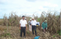
Figure: Interviewing village community staff for the survey. Credit: Nguyen Duy Nhiem. |
|
|
|
[ Tin tức liên quan ]___________________________________________________
|
(22).png "Community mapping in Vietnam: lessons learned")